
It's a Gas Energy Science-SMART! Home
![]()
Rock Hounds Who Sniff Out Gas
The pilot light on your stove goes out and your kitchen begins to smell like rotten eggs. Gas leak, you think to yourself. But that’s not gas you smell. It’s a chemical called mercaptan, which the gas company has added to make it easy for you to detect a leak. Natural gas itself is colorless and odorless. So how do gas companies find it underground?
"There are a lot of ways to look for oil and natural gas," says James A. Gibbs, a consulting petroleum geologist and independent oil and gas producer in Dallas, Texas. An oil seep on the surface of the ground is one telltale sign of gas below, since oil and gas are usually found together. Soil and airborne gas surveys that detect the presence of gas molecules in surface soil and air are another way of finding clues about the possible location of oil and gas. These methods are just the first step though, says Gibbs. What you really need to do is find the underground trap.
A petroleum geologist knows that in order for gas to be present underground, there must be a source rock that produced the gas, a porous reservoir rock (usually sandstone or limestone) that holds the gas, and an overlying bed of impervious rock, called a seal, above the reservoir rock to keep the gas from escaping. This configuration of rocks that allows the gas to be contained is called a trap.
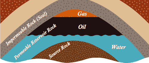 |
The source rock is the place where, millions of years ago, tiny sea plants and animals—called phytoplankton and zooplankton—lived, died, and were preserved. Source rock contains the source of the hydrocarbon. Shale is a common source rock.
|
How does a petroleum geologist find a trap? He or she might begin by examining aerial and satellite photographs of the site and mapping the surface. “From these surface maps,” explains Gibbs, “the geologist can project the geometry of the surface into the subsurface to see what rocks may be at depth.” The geologist might also make subsurface maps from data obtained by existing wells nearby.
The geologist will also conduct a number of tests—including gravity, magnetic, and seismic surveys—that supply data about the properties of the rocks below and thereby help the scientist to determine where these gas traps are located. “So you’re not really looking directly for the hydrocarbon, you’re looking for where the hydrocarbon might be,” says Gibbs.
Conducting a Seismic Survey |
|
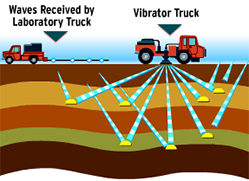 |
During a seismic survey, listening devices, called geophones, are placed in a line or checkerboard pattern on the ground. Then a series of shock waves—produced either by a dynamite blast or by special trucks equipped with pounding or vibrating machines—are sent underground. Wherever there is a change in the density of rock, which can occur between layers, the sound waves bounce back to the surface and are recorded by the geophones. The data is then assembled by a computer in a two- or three-dimensional record called a seismogram. |
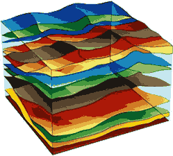
| 3-D Seismogram | |
|
Geologists analyze seismograms and use them to create a profile of the rock layers beneath the earth's surface that might reveal possible traps.
|
But even then, says Gibbs, “the only definitive test that you have for hydrocarbons is, unfortunately, a bore hole—a well. Because even though you’ve done everything you possibly can to determine the presence of a trap, you may get down there and find that the reservoir rock that you expected to see [is] plugged up.”
Gibbs adds, “It’s like a puzzle or an investigation, in which you take all these geological clues and you match your wits against the rocks and try to imagine where oil and gas could occur.”
Career Advice from a Petroleum Geologist
![]()